 | The Xenophile Historian |

 |
 |
 |
 |
 |
 |
 |
 |
 |
 |
 |
 |
 |
 |
A History of the South Pacific
Chapter 3: Pulled Into the Modern World
1781 to 1914
Part I
| Botany Bay | |
| Mutiny on the Bounty | |
| New Holland Becomes Australia | |
| The Impact of Western Contact | |
| Unrest In the Islands | |
| Kamehameha the Great | |
| Australia Developing | |
| The Last of the Tasmanians |
Part II
| Britain Claims New Zealand | |
| The Tahitian Kingdom | |
| A French Foothold on New Caledonia | |
| The Maori Wars | |
| The Kingdom of Hawaii | |
| There's Gold Down Under . . . | |
| . . . And in New Zealand, Too |
Part III
Part IV
| Dividing What's Left | |
| Hawaii, USA | |
| America's Imperialist Adventure | |
| Australia: Six Colonies = One Commonwealth | |
| New Zealand Follows a Different Drummer |
Tonga: The Restored Monarchy
Tonga was the only nation in the South Pacific that kept both its monarchy and independence until the end of the nineteenth century. There are two reasons for this: Tonga did not attract as many immigrants from abroad as Hawaii did, and it was ruled by an outstanding king, Taufa'ahau or George Tupou I. George did well because of his long lifespan, which, judging from his successors, runs in the family; his reign lasted from 1833 until 1893, when he died at the age of 95. For the first half of that long reign, George's priority was national unity; for the second half, it was preserving independence.
A nation takes an important step when it produces its first written code of laws, and George did this by writing a constitution in 1862. This began the task of leveling the inequality of power among his subjects. On the one hand the chiefs were declared the king's “nobles,” and their powers were weakened; on the other hand commoners were no longer required to do forced labor, and each adult male was promised two tracts of land, a garden plot in the countryside and a house lot in town. The king also created a privy council with members of his choosing, and a unicameral Parliament that contained both nobles and commoners. One unexpected result was that many men used their garden plots to grow cash crops, and this stimulus to the economy attracted merchants. To meet this challenge and deal with issues that weren't resolved by the first constitution, a second constitution was written in 1875. This document declared the king a constitutional monarch and is divided into three parts, according to subject: the rights of the people, rules on how the government functions, and rules concerning ownership, inheritance and sale of land. Because the 1875 constitution has worked out very well, it is still in effect today.
When the civil war of the early nineteenth century ended, there was one bit of unfinished business; the Tu'i Tonga ruler, Laufilitonga, was an enemy of George Tupou I. When he became Tu'i Tonga, Laufilitonga made a bid to regain the political power his predecessors once had, but Taufa'ahau/George defeated him in battle during the same year (1827), and after that he was only a potential threat to the king, not an actual one, so George was able to leave him alone for the rest of his life. In 1851 Laufilitonga was baptized a Catholic, since the paganism that had supported his office in the past was effectively dead. Then when he died in 1865, King George abolished the Tu'i Tonga title, meaning that Tonga would henceforth have one monarch, rather than two or three.
Because most of the outside nations Tonga dealt with were much stronger, George reasoned that the best way to preserve his country's independence was to cultivate good relations with other nations besides Britain. He got the chance to do this when Germany began sending ships to the Pacific in the 1870s. Consequently Germany and Tonga signed a treaty in 1876, that gave the Germans a coaling station at Vava'u in exchange for recognition of the Tongan nation.(56) The treaty had the side effect of persuading other nations to sign agreements that were also on favorable terms for Tonga; e.g., Britain and Tonga signed a treaty like that in 1879. Finally, in another move to keep Tonga independent, the king established a new denomination, the Free Church of Tonga, in 1885. While it did not replace the England-based Methodists completely, the Free Church of Tonga was a reassurance that Tongans could be Christians without coming under the rule of Christians from abroad.
Because George Tupou I ruled for such a long time, he was succeeded by a great-grandson, who had the native name of Siaosi Tupou II and the English name of George Tupou II. Though he enjoyed a reign of respectable length (1893-1918), it was less exciting than the reign of his predecessor, and that was a good thing when you consider that the second King George was not a competent ruler. That probably came from a lack of training/experience; the crown passed to him when he was only nineteen years old. To give one example, Parliament was suspicious of how the king governed, so it audited his accounts several times, and found discrepancies worth thousands of pounds.
However, George Tupou II probably could not have done anything about his biggest failing – a family life that was not good for the dynasty. A monarch is supposed to get married and have children as soon as possible, to insure that whenever his reign ends, the transition to his successor will be smooth. In this case, the young king was a bachelor when he came to the throne, so in 1898 he married Edith Marie Pomare-vahine, a granddaughter of Tahiti's Queen Pomare IV. However, she died just a few months later; for his next queen, the king chose Lavinia Veiongo. Unfortunately this queen was very unpopular, because she happened to be a great-granddaughter of Laufilitonga, the last Tu'i Tonga, and the people felt that someone from a disgraced and deposed dynasty had no business marrying into the current royal family. Because of that, the marriage almost started a civil war, and after they had a daughter, Sālote, the king was concerned enough about her safety to send her to a boarding school in Auckland, New Zealand, for five years (1909-14).
Queen Lavinia died of tuberculosis in 1902, forcing the king to marry once more. The third wife, ʻAnaseini Takipō Afuha'amango, came from an acceptable family, and this marriage lasted for the rest of the king's life, but she bore only daughters, guaranteeing that Tonga's next monarch would be female.
Because the government was a mess, and the king was in danger of being ousted by his subjects and European settlers, he signed a Treaty of Friendship on May 18, 1900, which declared Tonga a British protectorate. This arrangement allowed the monarchy to continue handling domestic affairs, but a British consul was appointed to oversee Tonga's defense and foreign policy. In 1905 the treaty was modified by a second one, which gave the consul the right to give advice and to appoint/dismiss government officials. To outsiders it looked like Tonga had been absorbed into the British Empire, but the monarchy and much of the traditional culture was intact, and the Tongans were safe from worse treatment at the hands of another colonial power, so as long as the British kept the terms of the treaties, the Tongans would be all right. And that is exactly what happened. Thus, in today's world the Tongans have fared better than the Fijians, Samoans and Hawaiians.
![]()
Cakobau Unites and Delivers Fiji to Britain
It took longer for Western culture to infiltrate Fiji than it did in Polynesia. For most of the seventeenth and eighteenth centuries, Europeans stayed away because the first explorer to come here, Abel Tasman, had warned of treacherous coral reefs. Also, the Fijians weren't very friendly to outsiders. The only people from outside Fiji that they liked much were the Tongans; for centuries Tongans had come to Fiji to trade, and often they served as mercenaries in Fijian wars. White men were only tolerated because they had guns. In 1822 Europeans founded Levuka, Fiji's first modern town, to handle the sea cucumber trade (see footnote #16), and it was not on one of the main islands, but on a secondary island, Ovalau.
As in other parts of the Pacific, the missionaries came next. The first Christian missionaries allowed in Fiji were sent by the London Missionary Society in 1830. More successful were the two Methodist missionaries, William Cross and David Cargill, who arrived in 1835. They did better because Tonga was Christian by now, and the Tongans helped; with them came emissaries from the Tongan king Taufa'ahau/George Tupou I, and Josua Mateinaniu, a Fijian from Vulaga who had converted while in Tonga. Then two Catholic priests showed up in 1844, thereby introducing the Fijians to Protestant/Catholic rivalry.
All of the above missions made slow progress, because they were men of peace, while unconverted Fijian chiefs preferred both war and cannibalism.(57) The first important convert was Ratu Ravisa (Varani), the chief of Viwa, who converted in 1845 and in turn became a Methodist missionary to spread the Good News. Then in 1847, Prince Enele Ma'afu of Tonga, the son of King Aleamotu'a/Josiah Tupou and the cousin of Taufa'ahau/George Tupou I, arrived to assume command over the Tongan troops in Fiji, a move which also gave the Christians an army to back them up. An even greater triumph came with the conversion of the Tui Nayau in 1849, for he was not just a local chief, but the ruler over the Lau Islands, meaning that his conversion opened up the whole east side of Fiji to the Gospel. However, the Tui Nayau was also supposed to be a vassal of the chief of Bau, Ratu Seru Epenisa Cakobau, so this is where the strongest Fijian leader of the mid-nineteenth century comes into the narrative.
Born around 1815, Seru Cakobau was the son of Ratu Tanoa Visawaqa, who had been the foremost chief of Bau during his childhood, until a power struggle with the subordinate chiefs forced Tanoa to go into exile in 1832. Initially Cakobau went with his father, but after he grew up he was allowed to return to Bau, because he had been too young to take part in all conflicts up to this point. In 1837 he led a coup against the current chief of Bau, and when it succeeded he reinstated his father as chief.(58) Tanoa's second reign lasted until his death in 1852, and predictably the successful son took charge of Bau next.
A fierce cannibal at this stage, Cakobau saw Christianity as a challenge. From his point of view, conversions weakened the army, so they might as well be desertions; even while his father was alive, he announced that the Lau Islands would be brought back in line by war. However, the presence of Ma'afu's troops in Lau forced him to back down. Ma'afu was now acting as the prince of all Tongans currently in Fiji; a war with Lau while Ma'afu was there would turn into a war with Tonga, and Cakobau did not have much of a chance of winning that. In the next battles between Bau and other Fijian factions, Bau lost, and soon there was rebellion against him on Bau itself. Thus, Cakobau was doing badly when the king of Tonga paid him a visit in 1853, on his way to Sydney. When Cakobau requested aid, George Tupou I replied, “It will be well for you, Cakobau, to think wisely in these days.” This meant that if he wanted the Tongans on his side, Cakobau would have to become a Christian and renounce cannibalism, so he reluctantly converted in April 1854.(59)
Fiji remained in a state of civil war for more than a decade after Cakobau's conversion, though his situation immediately took a turn for the better, now that Cakobau and the Tongans were working together. Cakobau started calling himself the Tui Viti, or king of Fiji, but most of the other chiefs did not recognize that claim; at best, they saw him as first among equals. While the battles remained fearsome, they changed in one aspect; captured enemies were now pardoned, whereas in pre-Christian days they would have been humiliated, killed and eaten. By the mid-1860s, most of the opposition had been crushed; Ma'afu dominated northern and eastern Fiji, while Cakobau was ruler over the rest. Ma'afu retired in 1871 so he wouldn't get in Cakobau's way, and that gave Cakobau firm control over the whole archipelago, except for the northern island of Rotuma.(60) So at this point, Cakobau declared Fiji a united kingdom, with its capital at Levuka. Following the examples of Hawaii and Tonga, Cakobau also decided he would be a constitutional monarch, and the first legislative assembly convened in the same year.
If you thought the story of Fiji ended here, think again. As soon as peace came to the islands, two new challenges appeared. The first challenge was European settlers; in the 1860s Europeans started moving in, especially at Levuka, now that Fiji was becoming a safe place for them. They bought land for plantations, and made a killing growing cotton during the years of the American Civil War, because the Union blockade of the Southern states caused a worldwide cotton shortage; they also grew coconuts on the side. The first British consul to Fiji, William Thomas Pritchard, acted way beyond his authority by establishing order and justice among Europeans, and making sure that relations between European and Fijian communities were stable. And thanks to the groundwork Pritchard had laid, when Cakobau set up his constitutional monarchy, both the legislature and the Cabinet were dominated by foreigners.
The other challenge, that from the United States, was worse. John Brown Williams, the first American consul, arrived at Levuka in 1846, and almost immediately demanded compensation for the Elizabeth, an American cutter that had been burned, run aground and looted in the same battle that killed Charlie Savage, back in 1813! Then in 1849, Williams threw a Fourth-of-July party that got out of hand; a shot from a cannon burned down his house. Though Cakobau was not even chief of Bau yet, let alone king, Williams felt he should pay the bill for the damages, estimated at $5,000. By 1855, the damage claim had grown to $18,331, and when it was combined with other damage claims from US citizens, the total amount was $43,686. Because Fiji had run out of sandalwood and sea cucumbers, the only way Cakobau could raise money to pay this debt was by selling Fijian land. Of course that is what the Americans had in mind; as with Tahiti and Hawaii, outsiders were now trying to gain control over Fiji by bullying the native rulers.
Debts would haunt Cakobau for most of the next two decades. If he denied responsibility for the American debt, he would in effect renounce his claim to the kingship, so he felt he would have to pay the debt, or get some foreigners to do it. In 1858 he made a proposal to Pritchard, offering to cede all of Fiji to Britain if the British would pay the American debt. British rulers thought it over, compared Fiji's assets with its liabilities, and then said “No” in 1862. Cakobau subsequently made the same offer to Tonga, and it was also rejected; the king of Tonga stated that Ma'afu was the only Tongan who had the right to rule in Fiji. Finally, in 1868 a group of Australian businessmen, the Polynesia Company, offered to take the debt off Cakobau's hands for a grant of 200,000 acres, near the village of Suva, and Cakobau felt he had to accept the deal.
Another wave of Europeans arrived after that, and the areas where they settled entered a state of lawlessness. The settlers bought land, often paying with weapons or alcohol instead of cash, and with no central authority, it was impossible to determine which land sales were illegal, or how to resolve disputed land claims. Tempers were high after cotton prices collapsed at the end of the 1860s and a tropical cyclone (hurricane) destroyed the 1870 crop. Therefore the Europeans accepted the constitutional monarchy when it was introduced in 1871. Unfortunately, this didn't end the economic and social unrest, and within a matter of months excessive government spending created another debt which Cakobau could not pay.
After considering all options, Cakobau decided that British rule was the least painful solution, and he sent Britain another offer to cede Fiji. The British position was that they would accept if the cession occurred with no strings attached, and after a year of negotiations, Cakobau agreed to this. The governor of New South Wales, Sir Hercules Robinson, showed up to represent Britain in the signing ceremony that brought Fiji into the British Empire; this took place on October 10, 1874.
As a British subject, Cakobau did all right. He gave up his title as king, but because he was still chief of Bau, he remained the second most important man in Fiji until his death in 1883. Robinson stayed in Fiji, acting as the first governor, until the arrival of an official governor appointed by London, Sir Arthur Hamilton Gordon.
Gordon managed Fiji from 1875 to 1880; his policies both shaped the future of Fiji and set the precedents for other governors to follow. He saw protecting the Fijians as his most important responsibility, and the recently concluded wars in New Zealand taught him much about governing an indigenous population.(61) The main thing he learned was that white settlers must not be allowed to have as much access to Fijian land and labor as they wanted; in other parts of the South Pacific that had been fatal to native communities. For that reason, the first thing he did was prohibit the sale of Fijian land to non-Fijians; he also made it illegal to force Fijians to work away from the plantations that employed them. To minimize the effect of modern economics, Gordon collected taxes from the Fijians in the form of crops (copra, cotton, candlenuts, tobacco, corn, and coffee), rather than cash. And because London expected Fiji to pay for its own upkeep, Gordon reduced the cost of his government by keeping the traditional tribal structure, and ruling indirectly through the chiefs. Finally, because Levuka did not have room for new buildings, the decision was made in 1877 to move the capital to Suva; this move was completed in 1882.
For this system to work, the settlers needed to prosper, but as in Hawaii, they could not find enough natives to work on their plantations. From 1877 to 1911, 23,000 workers were brought in from other parts of Melanesia, and most of them died of dysentery and tuberculosis. To make sure the workers had some immunity against Old World diseases, workers from the Old World would do best; Gordon chose Indians, because he had already seen them working on Mauritius. Thus, the first ship bringing workers from India arrived in 1879; by 1914, 60,969 Indian workers came over.
Typically the Indians were indentured workers, under a five-year contract which promised them free passage home when the contract was completed; in the meantime they sent part of their wages to their families, like the Chinese workers in Australia. However, Indians were encouraged to stay after the expiration of their contracts, though they had few rights in Fiji when they did so. At this stage the colonial government treated Indians as if they belonged to a lower social class than the Europeans and Fijians. The Fijians did not care much for the Indians, either (at least they had something in common with the Melanesian workers), and that led to a segregated society; there were few Fijian-Indian intermarriages, and the only fully integrated schools were Catholic schools (run by the Marist Brothers). Missionaries were the first to do something about this inequality; Hannah Dudley, the first European Christian missionary to the Indian community, arrived at Suva in 1897, and she encouraged making education and welfare programs available to Indians. We will come back to the topic of social progress on Fiji in the next chapter, because most of the changes were achieved after World War I.
![]()
The Unification and Division of Samoa
So far we have not discussed Samoa much in this narrative, and we will catch up on Samoan history now. The main reason for this is the hostile reception given to the European explorers that visited in the eighteenth century, especially Lapérouse. This convinced other Europeans to stay away, so official contact between Samoa (then called the Navigator Islands) and the world beyond the South Pacific was not established until the 1830s, when the first missionaries arrived. Therefore we only have oral histories to trace what happened before 1830, though Samoans claim these go back a thousand years.
The most unusual feature of Samoan history and culture is that would-be chiefs are expected to compete in order to prove they have the personal skills, fighting ability, oratory and wisdom to lead. For those who succeeded at these competitions, there were several minor titles, and those who accumulated enough of them would be qualified to receive the four major titles: Tui Arua, Tui A'ana, Gatoaitele and Tamasoali'i. A person who acquired all four major titles would gain the supreme title, Tafa'ifa, and thus be considered the ruler of all Samoa, but unlike the kingship in other civilizations, it was not a hereditary honor; the holder of it could only bequeath his home territory to his heirs.
Samoan legend teaches that the greatest native ruler before the European arrival was Salamasina, a woman who lived sometime in the fifteenth century. It is unclear whether whether she was the first to hold all four titles, but she not only had them, she also brought at least forty years of peace to the islands. After Salamasina the stories get confusing, to the point that it is questionable how many people became Tafa'ifa between 1500 and 1800, or even if any held the title at all; there isn't a continuous line of rulers, anyway.
At the beginning of the nineteenth century, there was a Tafa'ifa named I'amafana; with his death in 1802 the top position became vacant. During the interregnum, many Samoans thought that if anyone was eligible to become the next Tafa'ifa, it was Malietoa Vainu'upo, the designated heir of I'amafana. Instead, a warlord named Tamafaiga eventually gained all the titles – not by following the rules of the competitions between chiefs, but by raising an army and conquering the islands by force. The wars of conquest were completed in 1827 or 1828, and a brief tyranny followed. Tamafaiga mistreated the A'ana, the tribe of I'amafana, so badly that they conspired, and assassinated him in 1829. Another civil war followed (1829-32); during it, Malietoa Vainu'upo gained the Tui Arua and Tui A'ana titles, and after the war ended he was given the other two important titles because he had led the conquering side.
John C. Williams, the first missionary to Samoa, was sent by the London Missionary Society in 1830, so you can see from the above paragraph that he arrived in a tribal war zone. However, he found that Christianity was taking root in Samoa already; a few Samoans had visited Tonga and Tahiti, learned about Christianity in those places, converted, and brought back the new doctrine when they returned. Another factor that worked in Williams' favor was that Tamafaiga was gone, for he had been a militant pagan. Finally, Williams met a beachcomber named John Wright who brought him up to date on the Samoan situation, and acted as his interpreter. Malietoa Vainu'upo proved receptive, not only because he and his people needed to hear what Williams taught, but also because Williams told him that if the Samoans want Europeans to trade with them, they must become Christians.
Once Malietoa Vainu'upo converted, the rest of the Samoans soon followed. As expected, merchants and merchandise started coming; Apia was founded as a port to handle the needs of outsiders. In 1835 Methodist missionaries arrived to help in the effort to win souls to Christ. Then in 1839 Williams left to start another mission in the New Hebrides (modern Vanuatu), but here he came to grief; the natives of these islands killed and ate Williams, because they were tired of Europeans raiding Melanesia for sandalwood and slaves (see here). Back in Samoa, the number of believers grew quickly enough that some Samoans became ordained clergymen in the 1840s, and they traveled with European missionaries to assist in spreading the Gospel to the rest of the South Pacific. France sent the first Catholic missionaries in 1845, two Marist priests, and while they soon converted a decent-sized portion of the population, they also unwittingly introduced the Samoans to the European conflicts between Protestants and Catholics, between France and Britain.
Malietoa Vainu'upo died in 1841. His brother succeeded him as Samoa's foremost chief, but he could not be Tafa'ifa because Malietoa had divided his titles among more than one person. Malietoa probably thought dispersing the titles would start a new competition for them, but instead, because of the arrival of the Europeans, Western civilization and Christianity, there was a new game in town, so to speak. Disputes between the tribes caused Samoans to form two factions, the Manono and the A'ana; they fought a war from 1848 to 1851 and a number of skirmishes for the rest of the 1850s, all inconclusive. Afterwards the Samoans agreed that if there couldn't be any more Tafa'ifas after Malietoa Vainu'upo, then whoever ruled Samoa should come from the Malietoa family. They could still argue over which family member was best qualified, though.
Meanwhile, Apia rapidly grew to become one of the most important ports in the South Pacific, rivaling Levuka in Fiji, and Papeete in Tahiti.(62) Unfortunately, this meant that Apia, like other frontier towns, had also become an unruly, dangerous place; it soon was nicknamed “the Hell of the Pacific.” Some law and order was definitely needed, especially after 1857, when Godeffroy und Sohn, a company based in Hamburg, Germany, arrived to gather tropical products, especially copra (dried coconut) and coconut oil. Whereas previous merchants had been enterprising individuals, using their wits and whatever they could afford, Godeffroy was a full-blown corporation, and instead of relying on native merchants to bring the coconuts they asked for, the company would buy the land it needed for coconut plantations, and hire employees to work on them. Godeffroy did well for most of the 1860s; like the merchants in Fiji, the company took advantage of the American Civil War to grow cotton. And an economic slump in Samoa, caused by a drought, a tropical cyclone, and pests ravaging native gardens, put many Samoans in a desperate situation; to stay alive, they were willing to sell their land, and/or work on the company plantations. Ten years after Godeffroy came to Samoa, it had a trading network that stretched from Tahiti to the Marianas. The appearance of the first corporation in the South Pacific marked the beginning of a new kind of relationship between native islanders and outsiders.
At this stage, whatever arrangement of laws or authority that was set up to govern the foreign population would need the approval of the local chiefs in order to work, and the Samoan political system needed stability for that. It looked like stability had arrived in 1858, when the Samoans got a ruler whom everyone could accept, Malietoa Moli, but he died two years later. Two members of Malietoa family then arose to succeed Moli. Malietoa Talavou was Moli's half brother, while Malietoa Laupepa was Moli's son. A faction formed around each, and initially Talavou was more popular because of his seniority, but he could not proclaim himself king until all of Samoa supported him.
The two candidates campaigned for most of the 1860s to win total support; then suddenly in 1868 the chiefs and orators behind Laupepa declared him king, and set up a Western-style parliamentary government for him to lead. Talavou responded by raising an army to oppose the new government, and civil war ravaged Samoa for the next four years (1869-73). Talavou won most of the battles, because he had more warriors and canoes, but by 1873 even he was exhausted, and he agreed to rule jointly with Laupepa. Ultimately, the real winner of the civil war were those Europeans (especially the Germans) and Americans who sold guns and ammunition to the Samoans, who gladly and carelessly traded their land for arms. Thus, the war ended with foreigners holding 16 percent of Western Samoa.
Next, the Americans got involved. In 1872 the US Navy negotiated an agreement that gave them a coaling station in Pago Pago Harbor, on the island of Tutuila. This allowed the establishment of a shipping route from San Francisco to Sydney. Then the United States government sent a special agent, Colonel Albert B. Steinberger, to report on conditions in Samoa, and he used his influence to act as a kingmaker, too. In 1875 Steinberger drafted a constitution that replaced the dual kingship with a rotating one; Laupepa would rule for four years, after which Talavou or another member of his faction would rule for the next four years; meanwhile, Steinberger became Samoa's first prime minister. However, a year later other foreigners convinced Laupepa that Steinberger was working to advance the interests of the Germans, not those of the United States, so the king had Steinberger deported. But Steinberger had friends among Samoans in the government, and they in turn deposed Laupepa from the throne. Another civil war followed from 1876 to 1879, which ended when the three foreign powers involved (Germany, the United States and Britain) and most (but not all) Samoans rallied behind Talavou. Another constitution was signed on a German warship, the Bismarck, and Talavou was declared king for life. Eleven months later Talavou died, and in March 1881 his rival Laupepa was crowned king, in the presence of German, American and British consuls.
At this stage, it looked like Laupepa had triumphed. Still, in the civil wars mentioned above, he had lost many battles; he did not beat his opponents so much as he outlasted them. And during the most recent conflict, the Samoans had signed treaties with Germany, the United States and Britain that granted commercial and other rights to the foreigners, concessions so big that the consuls from those three countries now had more power over Samoa than the king did. When Laupepa's opponents rallied behind another chief, Tupua Tamasese Titimaea, and they revolted, the foreign consuls intervened in July 1881 to impose a cease-fire and a compromise government, which made Tamasese a deputy king. However, this government soon made itself unpopular by high taxation, and many suspected that the money collected was really going to the Europeans.
Fears that the Germans were about to annex Samoa prompted the government to send two petitions to Queen Victoria in 1884, pleading that Samoa be made a British protectorate. When the German consul, Theodore Weber, heard about this, he claimed the Mulinu'u peninsula, the land adjacent to Apia where the Samoan government was based. German sailors took down the Samoan flag and raised the Imperial German flag in its place, while Weber invited Tamasese to form a new government (1885); another German, Eugen Brandeis, became prime minister. However, the United States and Britain still recognized Laupepa's government as the rightful one. Thus, the stage was set for what is now called the First Samoan Civil War (1886-94).(63)
The Tamasese government made its move in August 1887, backed by a German warship; it defeated Laupepa and captured Mulinu'u. Laupepa tried hiding at first, then gave himself up because the warship would have bombarded his people if he continued to resist; the Germans exiled him to the Marshall Islands. That should have ended the war, but then Tamasese went too far by proclaiming himself Tafa'ifa, without acquiring all four of the titles required for that honor. Many Samoans, including a number of Tamasese's supporters, were offended; they also had the nagging feeling that Tamasese was nothing more than a German puppet. The opposition found another chief to back, Tupua Malietoa To'oa Mata'afa Iosefo, and launched a new rebellion in September 1888; the United States and Britain decided to support this new faction.
Soon the rebels bottled up Tamasese's warriors in the Mulinu'u peninsula, but could not finish them off because a German gunboat shelled rebel villages, drawing protests from British and American officials. Mata'afa's forces then plundered German plantations and wiped out an invading contingent of German soldiers. Furious, the German consul declared martial law; he requested that Germany send two more companies of marines, but Berlin turned him down, because that was likely to provoke US intervention. The British and American consuls in turn requested naval reinforcements, so a particularly intense moment came in March 1889, when seven warships – three German, three American and one British – confronted each other in Apia Harbor. Nowhere else did the nations of the West come so close to starting a war over a dispute in the South Pacific. You could say an “act of God” defused the crisis, because a tropical cyclone suddenly struck the harbor; only the British ship got away, while the other six were sunk and 155 sailors were drowned, despite the efforts of native swimmers to save them. Representatives of the three nations subsequently met in Berlin to end the war; because the Germans would not accept Mata'afa, they brought back Malietoa Laupepa from exile and made him king again.
The Samoans had no say in the arrangements imposed on them. Many still preferred Mata'afa; so did Robert Louis Stevenson, the Scottish author who had gone native here.(64) Hostilities broke out again in July 1893, and Laupepa's forces quickly defeated those of Mata'afa; this time it was Mata'afa's turn to be exiled to the Marshall Islands. Meanwhile another would-be king, Tamasese, had died in 1891, and his followers transferred their support to his son, Tupua Tamasese Lealofi I. The younger Tamasese made his bid for the kingship in 1894, but after a brief round of hostilities, he also surrendered to Laupepa's superior force.
Malietoa Laupepa died in 1898, and the question of who should be king came up once more. One month later Mata'afa was pardoned and returned to Samoa. This meant there were three candidates for the throne: Malietoa Tanumafili I (Laupepa's nineteen-year-old son, also called “Tanu”), Mata'afa, and Tamasese. The Unite States and Britain announced they would support Prince Tanu, while Tamasese withdrew his claim. However, most Samoans felt Tanumafili was too young, and that his installation as king did not follow Samoan custom, making it invalid; they (and the Germans) chose to back Mata'afa, and he was declared king on November 12, 1898.
The result of this maneuvering was the Second Samoan Civil War (1898-99). Feeling that leaving Mata'afa in charge would effectively give Samoa to the Germans, the Americans and British refused to back down, and sent ships and troops to help Tanumafili's faction. The allies won the first round of fighting; on the last day of 1898 the Chief Justice declared Tanumafili king, and Tamasese vice-king. Nevertheless, the conflict reached Apia in January 1899 with fighting in the streets, looting, and the burning of buildings. The Mata'afa faction and the Germans did better in this; Tanumafili and Tamasese were forced to live on a British warship for two months, to avoid assassination attempts. Then in March American and British warships returned and shelled Apia. Troops from those ships subsequently gained control over coastal roads but were unable to defeat the enemy in the interior.
Most wars were short affairs in the nineteenth century (World War I was fifteen years in the future, from this point), and the three foreign powers quickly got tired of this one when they realized it was becoming a stalemate. In June the Americans, British and Germans each appointed a commissioner to negotiate a settlement; we call their meetings the Tripartite Convention of 1899. Most of the terms were worked out in London, and the final agreement was signed in Washington, DC. As with the 1889 agreement, the Samoans were not allowed to participate at any stage of the process. In the end they decided that the only permanent solution for the instabilty was to abolish the monarchy, get both sides to give up their weapons (they were fairly compensated for this), and divide Samoa between the colonial empires.
Considering that Samoa had been the main spot of contention between the Western nations in the South Pacific, they came to terms more easily than you might expect. It helped that the British did not want anything in Samoa as badly as the Germans did, while the Americans were only interested in Pago Pago. The British ended up taking nothing, but in return for them dropping their claim, Germany had to give up all its rights in Tonga, including the coaling station, and Germany ceded the central third of the Solomon Islands to Britain (see this section). Tutuila and Manu'a were placed under American control, and have been known as American Samoa ever since. The rest of Samoa – 'Upolu, Savai'i, Manono and Apolima – went to Germany. Because 'Upolu and Savai'i are by far the largest islands, Germany got most of the land and the people. Apia became the capital of this territory, which would be called German or Western Samoa for most of the twentieth century. When they set up a new government, the Germans declared Mata'afa the “Paramount Chief” of Samoa, but that was just the number three position, above him were the colonial governor and Kaiser Wilhelm II, who was now declared the “Paramount King.” As for the ex-king, Tanumafili, he went to Fiji to get his university education.
![]()
Taming the Outback
After the gold rush, Australia had to deal with a whopping infrastructure problem; those folks who did not return to the countries they came from needed houses, jobs and land. This was felt most strongly in Melbourne, which had grown from 39,000 to 140,000 in just ten years. Because of the shortage of decent housing, in the 1860s about one fifth of eastern Australia's white population was living in shantytowns or tents. It was not unusual for a family of fourteen to live in just two small rooms, while outside the cities, bark huts with earthen floors were the norm, and families used cloth bags for beds and wooden crates for furniture.
It took an extensive building program, lasting through the whole 1860s, to turn the shantytowns into true city neighborhoods. The public buildings and fancier houses became the first examples of a distinctly Australian baroque architecture; the main features this style were Sydney lace ironwork, and domes on the largest buildings. Credit for most of this goes to an English architect named Joseph Reed, who tried unsuccessfully to make a fortune in the gold rush, but then went on to design the Melbourne town hall, the trades hall, and several banks and churches.
Solving the land problem required government intervention. Squatters had taken all of the good farmland before the gold rush; they rarely sold any of it, and when they did, the price was more than a recently arrived immigrant could afford. Something needed to be done about this; farms created jobs for people living outside the cities, but farms also required land. Moreover, the colonies needed to grow enough food to stop depending on imports from elsewhere, and the mutton and lamb that might come from the flocks of sheep was not enough. “Unlock the Lands” became the slogan of those who wanted land for farming but couldn't get it.
In their defense, the squatters argued that the wool from their sheep was Australia's most important source of income, especially now that the gold was running out. But by this time, most Australians had decided they wanted an egalitarian society, where unlike in Europe, a person's ancestry/family would not determine the opportunities he would have. This meant that land must be available to the poor as well as the rich. After bitter political struggles, by the end of the 1860s the Parliament of each colony ruled that individuals could buy a plot of land with a small down payment, and if they used the land to grow crops, they could make future payments without interest. Still, the squatters did not give up land to the farmers willingly. There were many occurrences of bribery and physical violence to keep the land; squatters might also play the same game by transferring their lands to an anonymous corporation, and then buy new land by pretending to be landless individuals. And those farmers who acquired land might give up later because they had to deal with either a flood or a drought every year – the bane of farmers anywhere. The colony with the most success at land reform was South Australia; within a few years it was growing enough wheat to export some of it to Victoria.
The next item that needed fixing was transportation, because there was lots of space between the cities, but too few roads, and the roads were unpaved, so many farmers could not get their crops to market. In addition, a colonial government might impose tariffs on goods brought in from another colony, and the hindrances that caused weren't worth the money collected.
By this time railroads were being built in much of Europe and the Americas, so that solution was tried in Australia, too; the first track, laid down in 1854, ran between Melbourne and the suburb of Williamstown. Unfortunately the colonies never agreed on what gauge to use on the tracks, so tracks with three different gauges were built, meaning cargo and passengers often had to switch trains when they went from one track to another. This problem bedeviled Australia for the next century and a half. Because of it, less than a thousand miles of track was laid by 1874, so the colonial governments and British investors had to get together in order to build the next 10,000 miles of track more quickly. Eventually everyone did agree on a standard gauge of four feet, eight and a half inches, but it took until 1970 to build an east-west railroad (from Sydney to Perth) all the way across the continent using this gauge, and a north-south railroad (from Adelaide to Darwin) wasn't completed until 2004. Even today a few minor lines still use a narrower gauge.
Behind the railroads, the other elements of modern civilization soon followed, like telegraph lines and trading posts. One of the most useful was a new invention, the barbed wire fence, because it could be built in deserts and dry grasslands, where it is too expensive to bring in enough wood for wooden fences. As on the Great Plains of North America, the introduction of barbed wire fences ended the era of the open range; now the owners of sheep needed fewer shepherds to control where their flocks grazed. Add to this the irrigation of lands near rivers, and both farmers and herdsmen found that if they developed the land properly, they could get rich off it whether they found gold or not. However, the eastern colonies (Victoria, New South Wales and Queensland) continued to experience most of the growth; progress was slower on the rest of the continent and on Tasmania. Western Australia, for instance, did not grow at a rate comparable to the eastern colonies until gold was discovered in the 1880s.
![]()
Ludwig Leichhardt
Of course, before the barbed wired fences could go up in the outback, the ranchers needed to know what kind of land they were putting them on. By the middle of the nineteenth century, the center of the continent had still not been reached by any white man, meaning more interior expeditions would follow. Nowadays, Australians mainly remember the explorers who did not make it back to civilization; the first of these since John Baxter was a Prussian scientist, Ludwig Leichhardt.
For his first expedition, Leichhardt and five other volunteers set off from Moreton Bay (in the neighborhood of Brisbane) in October 1844. The plan was to travel northwest, across the interior of Queensland and north-central Australia, until they reached Port Essington, a harbor in Arnhem land. On the way Leichhardt discovered good pastureland, five important rivers and two mountain ranges, all previously unknown, but he also proved he was a poor leader and not very good at living in the bush; they ran out of food quickly, meaning they had to take time out more than once to go hunting, and they lost more time because he frequently got lost. In his defense, Leichhardt and his companions ate plenty of native greens, and this kept them from getting scurvy, though they also suffered bouts of indigestion at the same time. One time he made the mistake of camping in an area of thick scrub, and the local aborigines used the bushes to sneak up; they killed one expedition member, John Gilbert, and wounded two others. Three thousand miles and fourteen months later, the expedition arrived in Port Essington, naked and starving; because Leichhardt had predicted the journey would take six months, everyone had given them up for dead. After returning to the east coast, he wrote an account of his adventures; this gained for him the title “Prince of Explorers,” and funding from the government and several individuals for a second expedition.
Next, Leichhardt went to the Darling Downs, a farming district on the west side of the mountains of Queensland, and got the second expedition ready. This time his plan was even more ambitious; starting from the Darling Downs, the expedition would head straight west, all the way across the continent; when they reached the west coast, they would follow it south to Perth. They moved out in December 1846, and the good luck that allowed him to complete the first expedition did not bless him again. Before they got out of Queensland, heavy rain halted their progress, the men caught malaria, and the cattle they brought for food ran away. After covering only 500 miles, the men turned east and returned to the coast. Meanwhile in Europe, Leichhardt was awarded gold medals from the British and French geographical societies, and though he never saw the medals, he heard about them, and that encouraged him to make another attempt to cross Australia. His third expedition left the Darling Downs in April 1848, and was never seen again. What happened is a mystery; most likely the expedition starved or died of thirst, or maybe some Aborigines killed them. The only clue we have is a brass nameplate with the words “LUDWIG.LEICHHARDT.1848”, which was found by an Aborigine in 1900. The name plate was on a burnt shotgun wedged into a boab tree, on the northern edge of Western Australia's Great Sandy Desert. The tree was marked with a letter “L”, and because we know that Leichhardt left his initial on other trees as he went along, this suggests that they took a northerly route, and they made it two-thirds of the way across the continent before perishing.
![]()
Edmund Kennedy
Another explorer active at the same time as Leichhardt was the English-born Edmund Kennedy. He had the leadership and wilderness survival skills that Leichhardt lacked, but was no luckier, and you need luck to succeed in the exploration business. As soon as he arrived in Australia, in 1840, he was hired by Sir Thomas Mitchell, the surveyor-general of New South Wales. Mitchell came from the previous generation of explorers; he had been knighted for discovering excellent pasturelands and mapping the rivers in the interior of New South Wales in the 1830s. Kennedy was the second-in-command on Mitchell's last expedition (November 1845-January 1847), an overland march from Sydney to explore the interior of Queensland, and map any rivers that might flow northward into the Gulf of Carpentaria (all rivers found to this point had flowed southwards). They did find a large river which appeared to go the way they wanted, which Mitchell named the Victoria, but at that point their supplies were very low, so instead of following the river, they turned back.
Mitchell was impressed enough by Kennedy's skills to appoint him leader of a follow-up expedition. Leaving Sydney in March 1847, Kennedy headed to the neighborhood of the Victoria River. Near the point where the previous expedition turned back, Kennedy decided they should travel light, so they buried their carts and the supplies they weren't going to use right away, to hide them from the Aborigines, and continued on their horses. While the river had initially taken a northwest course, Kennedy learned that it soon turned southwest, and joined the Thomson River to form Cooper's Creek, a river that had already been discovered by Charles Sturt. As for Cooper's Creek, it flowed into Lake Eyre, South Australia's largest desert lake, and thus did not reach the sea anywhere. Since the Victoria River turned out to be useless for transportation, Kennedy renamed it the Barcoo, using the name the Aborigines had for it. Returning to his buried cache, Kennedy found that the Aborigines had found it first, and contaminated the supplies by mixing dirt in the flour, leaving the expedition with no choice but to return to civilization; they made it back to Sydney in February 1848.
At this date, a lot of the ships coming to Sydney came from Singapore, Britain's wildly successful port in Southeast Asia. Those ships passed by Queensland, and because the northernmost part of Queensland, the Cape York Peninsula, had not been explored yet, the government decided that for his next expedition, Kennedy would find out what this region had. At Cape York, the northern tip of the peninsula, they would rendezvous with a rescue ship, the Ariel, at the end of 1848, for a ride back to Sydney. Or if they felt like exploring some more, they would go down the peninsula's western side, surveying the shore of the Gulf of Carpentaria; maybe the return trip from there would find the easy route through Australia's interior that had eluded the other expeditions.
In May 1848 Kennedy and twelve men traveled by ship from Sydney, and were dropped off at Rockingham Bay, in northern Queensland. It was a terrible place to start; the thick rainforest, rugged terrain and mangrove swamps made it almost impossible to move, especially for the livestock and carts. Nine weeks after they started, they had only gone 40 miles inland. Meanwhile on the coast, a ship named the Bramble was scheduled to bring them more supplies in August, but since the explorers were not following the coast, the Bramble never found them. In addition, the men and animals were steadily growing weaker, and hostile Aborigines were stalking the expedition. When they reached Weymouth Bay in November, Kennedy left behind eight men who were too sick to continue, along with two horses that were now only fit to use as food; before going on, Kennedy and the remaining four men slaughtered the rest of the sheep, and divided the supplies between themselves and those staying behind. The idea was that those who could continue would find the Ariel and bring this ship to Weymouth Bay, to pick up their sick companions. At Shelburne Bay, one of the men accidentally shot himself and had to be left behind, along with two other men to look after him; none of them were ever seen again. That meant only two were left to keep going, Kennedy and an Aborigine teenager named Jackey Jackey. The hostile Aborigines now had the opportunity they had been waiting for, and just thirteen miles from Cape York, they ambushed the party. Kennedy was speared, and died in Jackey Jackey's arms; though Jackey Jackey was also wounded, and had no more supplies, he survived in the bush for ten days, and caught up with the Ariel on December 23, 1848. After Jackey Jackey explained why he was alone, the Ariel sailed south; nobody was found at Shelburne Bay, while at Weymouth Bay, only two of the eight men left there were still alive. Finally in May 1849, the Ariel arrived in Sydney with the expedition's three survivors.
![]()
The Gregory Brothers
So far in this section, all you have read are stories of explorers coming to grief; two did not survive, while Mitchell failed to achieve the goals set for his last expedition. Well, in the 1850s two brothers came along who did better, Augustus and Francis (“Frank”) Gregory. Their father was an army veteran who had retired to the Swan River valley near Perth, so they started from here in 1846, taking their younger brother Henry Gregory, four horses and seven weeks' worth of provisions to explore the part of the outback north and east of Perth. Forty-seven days later they returned, after covering 953 miles. This was the only expedition where all three brothers traveled together; after this, Francis went on separate expeditions, while Henry acted as second-in-command on the ones Augustus led. When Augustus went forth again (1848), he went due north from Perth, and found pastureland worth settling near the Murchison River; this time he traveled 1,500 miles and was gone for ten weeks. For this he was made assistant surveyor of Western Australia.
If those expeditions did not impress you, the next ones should. Augustus Gregory accepted an offer to lead an expedition from Queensland into the interior. They had nineteen men, fifty horses and 200 sheep; taking a ship from Moreton Bay in August 1855, they followed Australia's northern coast, looking for a good place to start the overland journey. The day after they passed Port Essington, the ship ran aground on a reef, and it took eight days to free it, but otherwise the trip went without a hitch. Where the expedition disembarked, they discovered two rivers, the Victoria River and Sturt's Creek, so they split into two parties to chart their courses. After both groups returned to base camp, they waited through the dry season before going out again. When they were ready to go, in July 1856, Augustus Gregory wrote a letter in case they did not make it, and carved instructions on a boab tree for finding the letter; that tree is now a landmark called Gregory's Tree. From here they headed east-southeast, following almost the same path as Leichhardt had taken on his first expedition, except they were going in the opposite direction and they knew what they were doing. They reached the east coast in December 1856, about 300 miles north of Brisbane.
The success of the above expedition prompted the New South Wales government to hire Augustus Gregory, for an expedition to find out the fate of Leichhardt. Departing from Brisbane in March 1858, they found a tree marked with an “L,” then followed the Barcoo River until it became Cooper's Creek, but after that the countryside was so dry they turned south to save their horses, and ended up in Adelaide the following July. Meanwhile in Western Australia, Francis Gregory led four small expeditions between 1857 and 1861, to explore the rivers of that territory; in the process he discovered two to three million more acres suitable for grazing.
![]()
The Burke and Wills Expedition
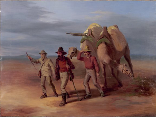
Because most of the outback was still a blank space on maps, in 1859 the government of South Australia offered a reward of £2,000 to the first man who crossed Australia from south to north.(65) The first to take up the challenge was an Irish ex-prospector, Robert O'Hara Burke. He prepared an expedition of nineteen men, twenty-three horses, and because of the close call Augustus Gregory had on his last expedition, they brought something new – twenty-six camels, imported from India. When the expedition left Melbourne in August 1860, a crowd of 15,000 gathered to see them off. However, they also took twenty tons of supplies, including a cedar camp table, a Chinese gong, firewood and dried meat (instead of live cattle), and that proved to be an unwise decision, because six slow-moving wagons were needed to transport all that stuff; three of the wagons broke down before they got out of the Melbourne area. It took them more than seven weeks to travel 470 miles to Menindee, the site for their base camp on the Darling River.
From Menindee, the plan was to have the expedition travel in two groups; for each stage of the journey the faster group would go on ahead, prepare a campsite, and wait for the slower group to catch up, with most of the supplies. This was safer than having everyone travel together, and by November they reached Cooper's Creek, the current edge of known territory. Now the southern hemisphere summer was beginning, and most of the expedition expected to wait there until March 1861, so they would not have to travel in the heat. But Burke grew impatient, when he realized that with the time they were taking, someone else might cross the continent first and win the £2,000 prize (he was thinking of John Stuart, see the next section). Accordingly, in December Burke decided to leave most of the men and supplies behind and make a run for the north coast, with just himself and six camels, one horse and three other expedition members, William John Wills, Charles Gray and John King. He also took a three-month supply of food and ordered those staying behind to wait for them at Cooper's Creek for three months.
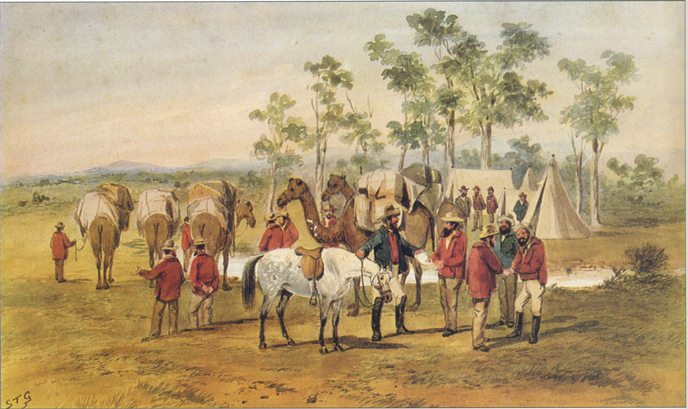
Summers in the Australian desert are notoriously hot; the temperature regularly goes above 120° F. in the day and can fall below zero at night. Aside from that, things weren't too bad; recent rains kept them from running out of water and the local Aborigines left them alone. In February they reached the Flinders River, which they knew flowed into the Gulf of Carpentaria. You would expect them to follow the river to its end so they could claim they had obeyed the rules of the contest, but they encountered a mangrove swamp so thick that they had to turn back, three miles short of the Gulf. They could not even see the Gulf from the spot where they turned around. Worse than that, it had taken two months to go this far, so it looked like they did not have enough food left for the return trip. On the way south, the rainy season began, adding another obstacle to hinder them. Pack animals were shot and eaten when they could not continue, and Gray died of exhaustion or dysentery, so three men and two camels were left when they staggered into the Cooper's Creek camp on the evening of April 21, 1861.
Return of Burke and Wills to Coopers Creek [King is shown but not mentioned], by Nicholas Chavalier.
Courtesy of the National Library of Australia Picture Collections, and http://www.schoolatoz.nsw.edu.au/ .
But the camp was deserted. A message had been carved on a coolibah tree – “DIG – 3 FEET N.W.” – and when they dug in the indicated spot, they found some supplies and a letter from William Brahe, the leader of the camp. The letter said that after waiting more than four months, Brahe had given up hope that the advance party would return, and they broke camp just nine hours before Burke, Wills and King arrived. Ironically, if Gray hadn't died, or if the other three hadn't stopped traveling for a day to bury him, they would have gotten back to the campsite before the rest of the expedition left.
What could they do? The first thought was to follow the other expedition members, back to Menindee and Melbourne, but they agreed that in their condition, they could not catch up. Plan B was to stay and wait for a rescue party. However, Burke had his way once more; he argued that because South Australia had some frontier settlements closer than Menindee, they should go in that direction. Before they started walking again, Burke wrote a message saying, “We proceed on tomorrow slowly down the creek to Adelaide, but we are very weak,” put the message in a bottle, and buried it under the “Dig Tree.” That course was the worst of three possible choices. Brahe and another man came back to the campsite a few days later for one more look, but missed Burke, Wills and King completely; they also did not think to dig under the tree, so they did not find Burke's note before they left again.
Soon the two remaining camels were dead, and without them, Burke, Wills and King could not carry enough water for a desert crossing, so they never left the vicinity of Cooper's Creek. At the end of May, Wills decided he wasn't going to make it on his own strength, so he returned to the campsite and buried his diary and journals in the Dig Tree cache. An Aborigine tribe gave food to Burke and King, but Burke refused to take assistance from people he considered inferior, and foolishly scared them away by shooting at one. After that they spent June trying to follow the tribe, but being malnourished, they continued to get weaker until Burke died. King returned to Cooper's Creek to find that Wills was also dead. When a rescue party came looking for them in September, only skeletons were left of Burke and Wills. King was the sole survivor, because the Aborigines took him in and fed him for the last three months, until he was rescued.
Burke and Wills were judged the winners of the Australia-crossing contest, though they did not live to receive the prize. Because of their tragic story, no explorers stirred the public imagination as much as they did. In December, the leader of the rescue party declared that "no less than five artists have commenced grand historical pictures of me burying Burke." Everybody decided that Burke and Wills had given their lives for the good of the whole Australian community. Even a rival, John Stuart, paid tribute; on his fifth expedition he named one of the rivers he discovered “Burke’s Creek after my brother explorer.” In 1863 the bones of those two pioneers were reburied in Melbourne and given Victoria's first state funeral; the crowd that witnessed it was estimated at 40,000. Monuments to them were raised all over Victoria, the most impressive being a great bronze statue from the governor.
![]()
John Stuart
It was John McDouall Stuart, a veteran explorer (not a beginner like Burke and Wills), who made the south-to-north Australia crossing and did everything right. We saw him once before, as a member of Charles Sturt's last expedition. Then for more than a decade, he was a private surveyor in South Australia. Because the gold rushes in Victoria were drawing away much of South Australia's male population, Stuart kept himself busy by looking for resources that might draw the men back: gold, copper, and land suitable for farming or grazing. For that reason, he went on six major expeditions between 1858 and 1862. The first expedition (1858) convinced everyone that Stuart was a competent explorer; he and two other men checked out the southern and western sides of Lake Torrens, discovered a string of waterholes and a stream that he called Chambers Creek, and wandered as far west as modern-day Coober Pedy(66) before returning to the coast. Most impressive of all, they survived for four months on rations that were only expected to last six weeks. But all Stuart got for his efforts was a gold watch from the Royal Geographical Society of London.
Stuart's second and third expeditions both began in 1859, and had Chambers Creek as the starting point. The main discovery of the second expedition was another valuable water source, springs to the west of Lake Eyre, fed by the Great Artesian Basin. For the third expedition, he simply surveyed the lands he had visited on the second expedition; several people were now claiming tracts in this area, and because this was leading to land disputes, somebody needed to mark the exact boundaries of each claim, including his own.
By now the previously mentioned contest to cross Australia had begun, and Stuart's fourth expedition was his attempt to go for the prize. Going forth in March 1860, he reached the center of the continent fifty-one days later, and answered the question of what was there – a prominent mountain. Stuart climbed the mountain, planted a British flag on top, and called it Central Mount Sturt, after his former boss; a few years later it would be renamed Central Mount Stuart. But after this point, the food was almost gone, all three men had scurvy, and 500 miles from the northern coast, their way was blocked by thick scrub. When the party came under attack by hostile Aborigines, they reluctantly turned around; fortunately, they all made it back to Chambers Creek in August, and Adelaide in October.
The fifth expedition was the largest Stuart had led to date, with twelve men, forty-nine horses, and thirty weeks worth of provisions. They started on New Year's Day of 1861; the summertime heat made this the worst time of the year to travel, but they were in a hurry to cross the continent before the Burke and Wills Expedition did. Their effort wasn't enough, for Burke and Wills reached the Gulf of Carpentaria when Stuart was only halfway to it. Still, as we saw previously, Burke and Wills did not survive the trip back, so let's see how Stuart succeeded where they failed. When he got to “Attack Creek,” the point where the Aborigines stopped him last time, the tribesmen weren't there – whew! However, after that they could not find an easy pathway; wherever they went, they either encountered more scrub or waterless desert. Eventually they did find a good river, which Stuart named Newcastle Waters, but while camped there, they again had to deal with low provisions, horses in poor health, and harassment from Aborigines, until on July 1, 1861, Stuart conceded defeat and the party turned south once more. Because it was now winter, the return trip was much quicker, and they reached Adelaide in September. Still, they had only gone 150 miles farther than they had on the fourth expedition.
Stuart's sixth expedition was ready to leave Adelaide in October 1861, only a month after the fifth expedition returned, but on the first day, Stuart's horse reared, knocked him unconscious and trampled his right hand. The expedition went without him to Chambers Creek, and waited there until Stuart caught up, five weeks later. However, it wasn't until January 1862 that he felt well enough to travel again, and he never fully recovered from those injuries. Because the path was now familiar, they managed to go all the way to Newcastle Waters in three months. Then came the tough part; not only were the Aborigines still unfriendly, but Stuart thought the Victoria River (previously discovered by Augustus Gregory) would be the easiest way to get to the sea, and try as they might, he and his scouts could not find it. It was when they gave up and headed north instead of northwest that they found a string of waterholes, and by following that, they reached the Mary River. On July 24, 1862, they came to the mouth of that river and stood on a beach facing the Timor Sea, a few miles east of present-day Darwin. To prove they made it, Stuart carved his initials on a tree, buried a tin containing a note nearby, and planted another British flag on the beach.
The worst part of the sixth expedition was the return trip. The horses were weak; rations were low; they had to search for water constantly. Hardship and the lack of food had ruined Stuart's health; he was now nearly blind, and for 400 miles was so sick that he had to be carried on a stretcher between two horses. On December 17, 1862, they reached Adelaide at last. To Stuart's credit, he did not lose a single man on any of his expeditions.
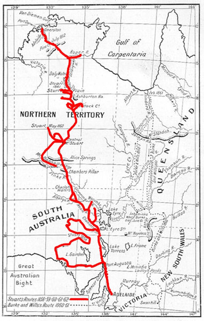
A map comparing the route of Burke and Wills (dotted line) with that of Stuart (solid red line).
Though Adelaide gave a parade in honor of the expedition members a month after they returned, not everyone was convinced they had done it, until the tree bearing Stuart's initials was re-discovered in 1883. Because he was a physical wreck, Stuart went to visit his sister in Scotland in 1864, and died in London two years later. Back in Australia, the success of his expeditions gave South Australia a claim to the north-central part of the continent. Previously, it had been an unsettled part of New South Wales, but the creation of Queensland separated it from the lands around Sydney. New South Wales agreed to give up the territory, a strip of it was ceded to Queensland in 1862, and the rest – what we now call the Northern Territory – was annexed by South Australia in 1863. Next, the Central Overland Telegraph Line was laid, going from Adelaide to Palmerston(67) and following the same route Stuart had taken in most places; it was finished in 1872. More recently the Stuart Highway was built across the continent, and it also roughly follows Stuart's Path.
![]()
And the Rest
Little else needs to be said to complete the story of Australia's exploration. Since everybody now had a good idea what was in the eastern third of the continent (Queensland, New South Wales and Victoria), the remaining expeditions were all in the central and western parts.
Among the last generation of explorers, John Forrest was the most successful. Starting out by working in the surveyor-general's office of Western Australia, he would lead three expeditions from Perth into uncharted territories, between 1869 and 1874. The first expedition was an unsuccessful attempt to find any clues about the fate of Leichhardt; it got as far as Lake Raeside in the desert, and Forrest hiked over some rich goldfields without knowing it. While he did not find Leichhardt or any land worth settling, Forrest got good marks for his careful observations, and for bringing back plant and mineral specimens for scientists. For the second expedition (1870) he traced Eyre's longest route in reverse, going overland from Perth to Albany, and then following the southern coast all the way to Adelaide. Because their expedition was better planned and equipped, they didn't suffer as much as Eyre did, though they found it just as much of a challenge to find water. Also worth noting is that one of the six men on the expedition was Forrest's brother Alexander, who would become an explorer in his own right after this.
Since Australia had been crossed from south to north, Ernest Giles, a former prospector, post office clerk and bushman, decided he wanted to be the first to make an east-west crossing. However, his first expedition was more humble; in 1872 he led a small group into the central part of the continent to explore the lands west of the new telegraph line. Using an unusually tall and thin mountain called Chambers Pillar as his starting point, he followed the Finke River and Macdonnell Range until a shortage of water forced him to turn back. When he returned to Adelaide, his patron, Baron Ferdinand von Mueller, immediately began raising funds for a second expedition, and that allowed Giles to go forth again in 1873. This time he started from a river that flowed into Lake Eyre, and headed west again; the land here was extremely dry as well, making it a constant struggle to get enough water for the horses. At the westernmost point reached, around longitude 126º E, Giles and another man, Alfred Gibson, were scouting ahead, when Gibson's horse dropped dead. Giles gave him his own horse and told him to follow their tracks back to the expedition camp, and he would return to the camp on foot. Eight days later an exhausted Giles showed up in camp, only to find that Gibson never made it there. The expedition tried searching for Gibson, but after a few days they had to give up, for their supplies were so low that it was time to go home again (May 1874); Giles named the desert they explored after his lost companion.(68)
Another explorer, William Gosse, was trying to cross central and Western Australia in the same year as Giles' second expedition, 1873. He also had to turn back when the water ran out, but he succeeded in discovering Ayers Rock, the most famous geological feature in the outback. A third explorer in the neighborhood, Peter Warburton, did the best of all. Leaving Adelaide in September 1872, Warburton's expedition followed the telegraph line to Alice Springs, then turned west for a nearly straight course across the Great Sandy Desert. We now believe Leichhardt came this way, a quarter-century earlier, and Warburton may have barely avoided the same fate. Because of the searing heat and lack of water, they killed and ate all but two of their camels to survive. By the time they reached a sheep station (ranch), all six men had scurvy; Warburton was nearly dead, blind in one eye, and tied to one of the last camels. In January 1874 they reached the coast at Roebourne, a point roughly 800 miles north of Perth, and caught a ride on a ship to get back to Adelaide. For making it, the South Australian government awarded £1,000 to Warburton and £500 to the rest of his party.
Impressive as that was, an east-west crossing that went through the center of the continent would have been more helpful, to complete maps of the interior. For that reason, John Forrest's third expedition (April-November 1874) would do that; the plan was to go to the Murchison River, follow it east to its source, keep going overland until the party reached the telegraph line, and then turn south for the familiar hike to Adelaide. Again, Alexander Forrest was one of those who went. Along the Murchison they had easy going, and discovered some more pastureland, but after that conditions were extremely arid, even though it was wintertime. Often the party was critically short of water, and more than once they had to abandon some of their horses; John Forrest found out the hard way that he should have brought camels instead. They managed to survive because of some well-timed thunderstorms, and the discovery of two fine water sources, Weld Springs and Elder Springs. At the end of September they reached the telegraph line, and since the land they passed through after this was being settled, the last part of their journey saw them receive a hero's welcome at every station or community they passed.
Next, Ernest Giles finally made the crossing he wanted. His third expedition (in South Australia, 1875) started at Beltana on the telegraph line, followed the south coast as far as Eucla, and was cut short because like Eyre and Forrest, he found that area to be very dry. From Sir Thomas Elder, the man who introduced the first camels to Australia, he acquired some camels for his fourth expedition (also in 1875). Starting at Port Augusta, Giles went around the east and north sides of Lake Torrens, and then headed due west across the desert, taking a course roughly parallel to latitude 29º S. By the time they entered Western Australia, the land was so desolate that Giles wrote, "I have never visited any part of Australia so devoid of animal life." Then he found out why there were no animals around; for twelve days they had to travel without finding any water. An aborigine guide saved the day by finding water at a place they named Queen Victoria Spring; likewise the surrounding dry lands were called the Great Victoria Desert. The main event after that was a skirmish with some hostile Aborigines who may have thought the explorers and their camels were drinking too much of their water (camels will do that, when given the chance!). The worst part of the journey ended when they met a stockman looking for lost horses, and he was able to guide Giles to the nearby stations, and eventually to Perth.
After resting in Perth for two months Giles made another overland crossing, in 1876. Although this is called his fifth expedition, it was really the fourth expedition's return trip. For this journey he went north from Perth, crossed the Murchison and Gascoyne Rivers, and then turned east, taking a route that ran about 400 miles north of the previous one. This brought him to the Gibson Desert again, and he searched again in vain for Gibson's body. After that Giles went to the telegraph line and Adelaide by simply following the same path he had taken on his second expedition; again, having camels for desert travel made the journey easier than it had been when he had horses. But all he got for his efforts were £500 from the South Australian government, and some awards and honorary memberships, largely because he did not lose any men besides Gibson. He did not get much recognition for his crossings because Warburton and Forrest had made theirs first; nor had he discovered anything very interesting or useful, and nobody gave him a government job, which was what he wanted the most. In that sense, Giles was the unluckiest Australian explorer who lived to tell about his adventures.
On his own, Alexander Forrest led two expeditions. For the first, in 1871, he went from the Swan River to the Great Victoria Desert and back; in a nutshell, he made a thorough reconnaissance of Australia's southwest corner. His second, in 1879, followed the northwest coast, from the De Grey River to the Fitzroy River, and then he went inland to explore the Kimberley Plateau and Arnhem Land. This expedition was more useful than the first, because it discovered a new area of pastureland. As for John Forrest, he did no more exploring, though he was only twenty-eight years old. His successful expeditions made him so popular, that he was awarded 5,000 acres of farmland, a gold medal from the Royal Geographical Society of London, and promoted quickly through the ranks of the surveyor-general's office. That put him in charge of completing another telegraph line, from Perth to Adelaide, in 1877, and this added Western Australia to the British telegraph network (see footnote #65). By 1883 he was the surveyor-general; from there he went into politics, was elected to the colony's legislative assembly, and became Western Australia's first premier in 1890. The following year saw him become the first person born in Australia to be knighted, and he served as premier and treasurer until 1901. Finally he was promoted to the peerage in 1918, meaning he was a baron for the last seven months of his life.
The last expeditions worth mentioning were two south-north crossings of the deserts in Western Australia; both took place in 1896, twenty years after Giles was finished. Starting from Lake Barlee, a lake in the desert near Perth, Lawrence Wells led a party to the Fitzroy River, while David Carnegie took a more easterly course and led his party from Lake Barlee to Sturt's Creek, before returning by way of the Gibson Desert. With this, the continent's exploration was complete, 126 years after James Cook came to the east coast. After this, settlements would be established, and others would come to exploit the pastureland and mineral wealth of the outback. And because independence was approaching, Australia was certain to become a rich country, now that it could take advantage of its vast resources.
![]()
The Bush Culture
The explorers mentioned in the previous sections were not the only heroes elevated by the Australian people. They also idealized the culture of “the bush.” Because it took a self-reliant attitude to survive in such a forbidding land, what we now call “rugged individualism,” Australians greatly admired those who did it. They wrote stories, songs and plays about people in the outback such as prospectors, squatters and “swagmen” (temporary workers). “Waltzing Matilda,” a song of a swagman's clash with some squatters, became the most famous and best-loved Australian song, the country's unofficial national anthem. The most popular place for Australian literature and opinions in the late nineteenth century was The Bulletin, a magazine which was published from 1880 to 2008; it was nicknamed the “Bushman's Bible” for the part it played in developing the bush culture, and later Australian nationalism.
At its best, The Bulletin promoted “mateship,” the idea that all men were brothers in a classless society. However, the material which appeared in The Bulletin was controversial, because it promoted sexism and racism at the same time. When women appeared in cartoons and stories, they were either sexy maidens or nagging wives. As for nonwhites, the Aborigines were portrayed as friendly but not too bright, while the Chinese were lazy if friendly, and schemers if they weren't. Gradually, fear and prejudice also arose against the Melanesians brought in to work the sugar cane plantations; in any given year, there could be as many as 50,000 of them in Queensland. At first, the magazine's masthead featured the slogan “Australia for Australians,” but in 1886 it was changed to “Australia for the White Man,” and this slogan lasted until 1961. The Bulletin's success helps to explain the white supremacy policy that the Australian government practiced for much of the twentieth century.
One resident of the outback was even more popular than the swagmen and squatters: the outlaws, also called bushrangers. These were the armed robbers that prowled the frontier, those who were called bandits and highwaymen when they appeared in other places besides Australia. They mainly stole horses and robbed stagecoaches; they could either be escaped convicts or individuals who decided that a life of crime was the easiest way to get rich. Because the bushrangers weren't hindered by poor roads or communications, they could often outwit the authorities, winning the admiration of those who knew that the police were brutal and incompetent.
The most celebrated bushranger was Ned Kelly (1854-80). The son of an Irish couple who lived in rural Victoria, he first got in trouble with the law in 1870, when he was arrested for associating with another bushranger, convicted of stealing cattle and horses, and sentenced to three years in prison. After he got out, he moved up to bank robbery and the murder of policemen, while boasting that he and his gang had never harmed a woman or robbed a poor man. This wasn't true, but it encouraged many poor Australians to see Kelly as a Robin Hood-type character. A two-year rampage followed, which ended in 1880 when Kelly made his last stand, by holding sixty hostages in a hotel in the town of Glenrowan. The police managed to kill most of Kelly's gang by setting the hotel on fire, and shooting those gang members who tried to escape. Kelly came out with guns blazing, but was wounded, captured, and taken to the jail in Melbourne. His admirers sent petitions calling for his pardon, which reportedly had 30,000 signatures, but instead he was hanged a few months later.
Kelly's execution marked the end of the bushranger era, for as railroads and telegraph lines were built across Australia, it became harder and harder for them to keep one step ahead of the law. More than 130 years after his lifetime, Kelly remains one of the most easily recognized, and most controversial figures in Australian history; today's Aussies see him either as a cultural icon, or a murderous villain who got what he deserved. Australian film makers have made more than one movie about Kelly (1906, 1970, 2003); the two most recent ones had Mick Jagger and Heath Ledger in the lead role. The historian Geoffrey Serle explained Kelly's continuing popularity by saying Kelly and his gang represented "the last expression of the lawless frontier in what was becoming a highly organised and educated society, the last protest of the mighty bush now tethered with iron rails to Melbourne and the world."(69) Martin Flanagan, an Australian columnist, went so far as to compare Ned Kelly with Jesus, and claimed Kelly is popular precisely because he is controversial: “But what makes Ned a legend is not that everyone sees him the same -- it's that everyone sees him. Like a bushfire on the horizon casting its red glow into the night.”(70)
The last decades of the nineteenth century were a time of impressive growth for Australia, for the same reasons that the United States saw growth at this time: the country's frontier was open for settlement, and rapid technological advances. In 1880, native-born Australians outnumbered immigrants, for the first time since their cities were founded (up to this point, nearly all Australians and New Zealanders mentioned in this chapter were immigrants born in Europe). Much of the growth was fueled by British capital, for Britain now saw Australia as an ideal place for investments, and the Australians agreed. To add to the mineral riches already mentioned, copper was discovered in Queensland, and Broken Hill in New South Wales became an excellent source of silver, lead and zinc; meanwhile, the continent's coal production tripled in a twenty-year-span. In the agricultural sector, sugar cane was doing great in Queensland, and a drought-resistant strain of wheat meant there would be harvests even in dry years.
Life was getting better for workers in the cities as well. From the start, skilled workers like carpenters and stonemasons had been able to demand high wages, because they were in short supply. They also formed craft associations, that soon became labor unions. By 1855, skilled workers in Melbourne had won their demand for an eight-hour workday, and their unions were granted legal recognition in 1870. This success encouraged the creation of unions for those working out of town, like miners and sheepshearers. Thus, Australia had an unusually strong labor movement, when labor movements in Europe and the Americas were struggling to win acceptance by the general public.
Foreigners agreed with Australians that their country was becoming a “workingman's paradise.” Anthony Trollope, an English writer, visited Australia in 1872, and let everyone know that the Australian worker was better off than his counterpart in England; he said the typical worker was "better fed than the laborer at home, better housed, better clothed, and is therefore more of a man." He especially had praises for Melbourne: "There is perhaps no town in the world in which an ordinary workingman can do better for himself. He not only lives better with more comfortable appurtenances around him, but he fills a higher position in regard to those around him and has greater consideration paid to him than would have fallen to his lot at home."(71)
Unfortunately, at the end of the 1880s the Australian economy overextended itself. During the boom, more than £200 million had been borrowed to pay for the erection of new buildings, or to bring poor-quality land under cultivation. When the economy of Argentina crashed in 1890, the British bank which had lent the most money to Buenos Aires went out of business. This made other banks leery of lending money for risky ventures anywhere, and in Australia, the speculative bubble burst.
Sydney saw a massive strike over the dismissal of a union official on a steamship, the Corinna. First the union members went on strike in protest, then 50,000 workers in other trades showed their mateship by joining them. The strike only lasted six weeks, because public opinion was overwhelmingly against it, forcing the strikers to back down, but after they returned to work, a depression followed, bringing widespread unemployment and hunger. Though many blamed the unions, a lack of confidence was the real reason why the economy did not bounce back. More than forty land and finance companies failed in 1891 and 1892, and most building projects, both private and public, came to a abrupt halt. Banks raised interest rates to keep English investment coming in, but panic-stricken depositors withdrew their funds, until January 1893, when the Federal Bank and twelve other banks closed their doors and suspended all trading. Melbourne lost its status as Australia's financial center, and the depression was a rude shock to the whole continent, whose people had come to believe that the good times would last forever. Outside of the cities, a badly timed drought hurt the farmers and sheep industry.
One product of the depression was that the trade unions defended the rights of their workers more strongly than they had previously. Another was the idea that those favoring the unions should get into politics, leading to the establishment of the Australian Labor Party. This was the first step in a smooth process that would lead to independence, right when the twentieth century began; we'll cover that in another section, after we catch up on what was happening in the Pacific.
This is the end of Part III. Click here to go to Part IV.
FOOTNOTES
56. We haven't mentioned it previously, but in the middle of the nineteenth century the world's advanced nations switched from sails to steam engines as the means to move ships. Coal was a more efficient fuel than wood for steam engines, but because the Pacific Ocean was so big, steamships were not expected to have the cargo space needed to carry enough coal for a non-stop crossing. Therefore each nation with ships in the Pacific had to make sure it had enough coaling stations for those ships to refuel in the middle of their journeys; we already saw the Americans trying to get a station at Honolulu, Hawaii, for instance.
57. We saw previously that Fiji was notorious for cannibalism. The most voracious cannibal on record was Ratu Udre Udre, a Fijian chief in the early nineteenth century. Udre Udre believed that if he ate 1,000 people, he would become immortal, and he came pretty close to achieving that goal, by consuming at least 872 bodies (all warriors killed in battle) during his lifetime. To keep track of the number of victims, he collected one stone for each, and those stones now decorate his grave. Alfred Packer and Jeffrey Dahmer, you were just beginners!
58. He got the name Cakobau from this event, which meant “Destroyer of Bau.” Another name of his was Cikinovu, meaning Centipede, "because he moved silently and struck painfully."
59. However, this was a partial triumph for Christianity, not a complete one. Most Fijians who converted did not give up their pagan practices completely. And missionary work could still be dangerous. The worst example came when the Methodist Church sent a Reverend Baker into the western highlands of Viti Levu; natives in that area killed and ate him in 1867, because they saw him as an agent of Bau!
60. Rotuma had to be different; unlike the rest of Fiji, its population is Polynesian, not Melanesian. It stayed independent until 1881, when Britain annexed the island.
61. Though Gordon succeeded at protecting the Fijians from exploitation, he could not keep them safe from disease. There was a really bad outbreak of measles in 1875, which killed a third of the Fijian population.
62. Great Britain established a consular office in Apia in 1847. The United States established one in 1853, and the Germans did the same in 1861. The German consulate represented just Hamburg and Godeffroy until the unification of Germany in 1871.
63. I don't know why the name “First Samoan Civil War” is used, because we saw in this section that there were at least four civil wars before 1886. Maybe it is because this was the first time outsiders got involved as anything but peacemakers. Also, the beginning of the war was when Laupepa accepted a proposal from the Kingdom of Hawaii for an alliance (see footnote #52).
64. We mentioned Robert Louis Stevenson already, in footnote #50. The man who gave us Dr. Jekyll and Mr. Hyde, and Treasure Island, had been traveling around the South Pacific since 1888 because of poor health. In 1890 he arrived in Samoa, built a house in the village of Vailima, and gave himself the native name of Tusitala, the “Teller of Tales.” The Samoans loved him because he got involved in local politics on their behalf; his book A Footnote to History is both an account of the First Samoan Civil War and a denunciation of European officials in Samoa, whom Stevenson called incompetent. However, his death in 1894 kept him from writing about how the war ended.
65. One new factor that promoted exploration was the invention of the telegraph, the first instantaneous form of communication, by an American named Samuel Morse. In 1853 Samuel Walker McGowan, an associate of Morse, sailed to Melbourne in 1853, for the purpose of introducing the telegraph to Australia. By this time, Britain had built telegraph lines all the way to India, and the technology had been developed to lay telegraph lines under the sea, thereby connecting islands with the continents. Naturally Australians wanted to become part of the growing telegraph network, and among the proposals for undersea cables connecting Australia with Asia, the shortest (and cheapest) possible route would run from Indonesia to Arnhem Land. In fact, it would follow the same route that we believe the ancestors of the Aborigines used to reach Australia (see Chapter 1). The problem was that the land on the Australian shore, the future Northern Territory, had not been explored yet, and from there the cable would have to cross more than a thousand miles of land to reach Australia's cities; most of that land had not been explored, either. Hence, the reward mentioned above.
66. The stones at Coober Pedy hurt the hooves of Stuart's horses, and that convinced him that he had done enough exploring for this trip. What he did not know was that the world's richest opal deposit lay beneath those stones. That was a mineral resource he would have wanted to find, for sure! Instead, it wasn't discovered until 1915. Because the weather at Coober Pedy is too hot or too cold most of the time, today's opal miners and their families live underground.
67. One of the most famous research ships of history, the HMS Beagle, surveyed Australia's north coast in 1839. The ship commander, Lieutenant John Lort Stokes, discovered a promising harbor and named it Port Darwin, after another crew member he used to share a cabin with, Charles Darwin. When a city was founded there in 1869, it was first named Palmerston, after a British prime minister. Then when the Northern Territory was established in 1911, Palmerston was renamed Darwin, and became its capital.
68. "I called this terrible region, that lies between the Rawlinson Range and the next permanent water, which may eventually be found to the west, 'Gibson's Desert,' after this first white victim of its horrors." From Giles, Ernest, Geographic travels in Central Australia from 1872 to 1874, Melbourne, M'Carron, Bird and Co., 1875, page 195.
69. Serle, Geoffrey, The Rush to Be Rich: A History of the Colony of Victoria 1883-1889, Melbourne University Press, 1971, pg. 11 (ISBN 978-0-522-84009-4).
70. Flanagan, Martin, Rebels who knew the end was coming, but stood up anyway. From The Age (Victoria edition), March 30, 2013.
71. Every year the Economic Intelligence Unit rates cities around the world, according to their quality of life. Since 2011, they have proclaimed Melbourne the “world's most livable city.” Apparently Melbourne worked for more than a century to get to the top of the list!
Support this site!
![]()
PAGE NAVIGATOR
A History of the South Pacific
|
Other History Papers |
Beyond History
|